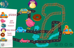
 First graders at Trevvett Elementary have been learning about maps (SOL1.4) and how to make maps with symbols and a legend (SOL1.5). Today, students in Ms. Robinson’s class created their own maps with ABCYa! Paint. First, we drew some land and water features. Next, we used the rainbow brush to paint roads, railroads, and rivers on our map. I explained that rivers usually flow into the ocean and roads and railroads need to go to different parts of the land. Then we looked at the stickers and discussed what they could symbolize. For example, a loaf of bread could be a symbol for a bakery and the Earth could be a symbol for a science museum. They added sticker symbols to their map, and they also added them to their map legend. The last step was to use the text tool to type words next to the symbols in the legend, explaining what they mean. We saved our maps and uploaded them to a Lino board (it’s similar to Padlet, which recently changed its policy for free accounts). You can see their finished maps here. (UPDATE: I taught a similar lesson in Ms. Shelly’s class at Holladay, and you can see their maps here).

