
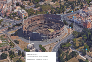
 Third graders at Holladay Elementary have been studying ancient Greece and Rome in Social Studies (SOL3.1) and measurement in Math (SOL3.9). Today students in Ms. Middleton’s class practiced measuring the Roman Colosseum using Google maps. I previously taught a lesson on measuring the Parthenon, but I wanted to show them the new 3-D feature, so we looked at the Colosseum today (the Parthenon isn’t in 3-D yet). First we found Italy on the map and discussed its shape (peninsula) and the Mediterranean Sea that surrounds it. Then we zoomed into Rome and looked for the Colosseum (it’s called “Colosseo” on the map). Once we were close enough to see its circular shape, we switched to Google Earth view (click the button in the bottom left corner) and clicked the 3-D button on the right. I showed the students how to hold down the CTRL key and click and drag to rotate the view. They were amazed that all the buildings and terrain were in 3-D! It’s a great way to show students the hilly landscape. It also helps develop map skills (SOL3.4). Now it was time to measure the Colosseum. We discussed what unit we should use, and we made an estimate on Padlet. Then we right clicked on one side of the Colosseum and clicked “Measure Distance.” When we clicked the other side, it automatically gave us the distance across. We used the Snipping Tool to take a screenshot, and we uploaded our screenshots to the Padlet. You can see them all here.

