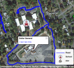
 Today 1st grade students at Chamberlayne Elementary created their own community maps using ScribbleMaps (SOL1.4 & 1.5). Since I knew it would be kind of tricky for 1st graders to find their school on the map, I put a direct link to it in their classroom folder on the computers. With ScribbleMaps, there’s no log in so we could get started right away. First we talked about what we saw on the map and how it showed their community from above. We located their school and the different parts (playground, bus loop, cafeteria, their classroom, etc.), and we also located the nearby shopping center. I showed them how to select a color and size for the marker tool and they drew on the roads. Then we clicked the “Create a Legend” link in the top left, and they added a colored line to the map key identifying it as a road. Next we discussed how maps often use symbols for places, so we clicked on the “Place Marker” tool and added a symbol of a school to our maps (it can be found in the Places folder under “Geology/Locations”). We also added that same symbol to our map key. Finally we went to the folder called “Places-High Detail” and found a symbol of our choice to represent the shopping center. We added that to the map and to our map key. Each symbol on the map has a label so we labeled the school “Chamberlayne Elementary” and the shopping center “Dollar General.” Some students went on to add descriptive sentences (photos can also be added to the labels). Since I wanted to publish all of their maps to one page for easy access, I created a form for them to copy and paste their links (I had to help with this). Then I published the results here.


